The Bronx River: A River of Our Own
Researched and written by Lesley Topping
Historical consultant, Barbara Shay MacDonald
The beauty of the Bronx River has stolen the hearts of many artists, writers and local residents. It was a frequent subject for the American Impressionist painter, Anna Richards Brewster (1890-1957) who lived near the river in Scarsdale.

Fenimore Bridge by Anna Richards Brewster, circa 1930. Courtesy of the Scarsdale Library Collection.
Westchester historian Helen Hultz opens her 1,000-page handwritten history of Scarsdale with an ode to the Bronx River, in which she describes its wintery landscape as “silent witnesses of the ancient heritage that belongs to Scarsdale.”
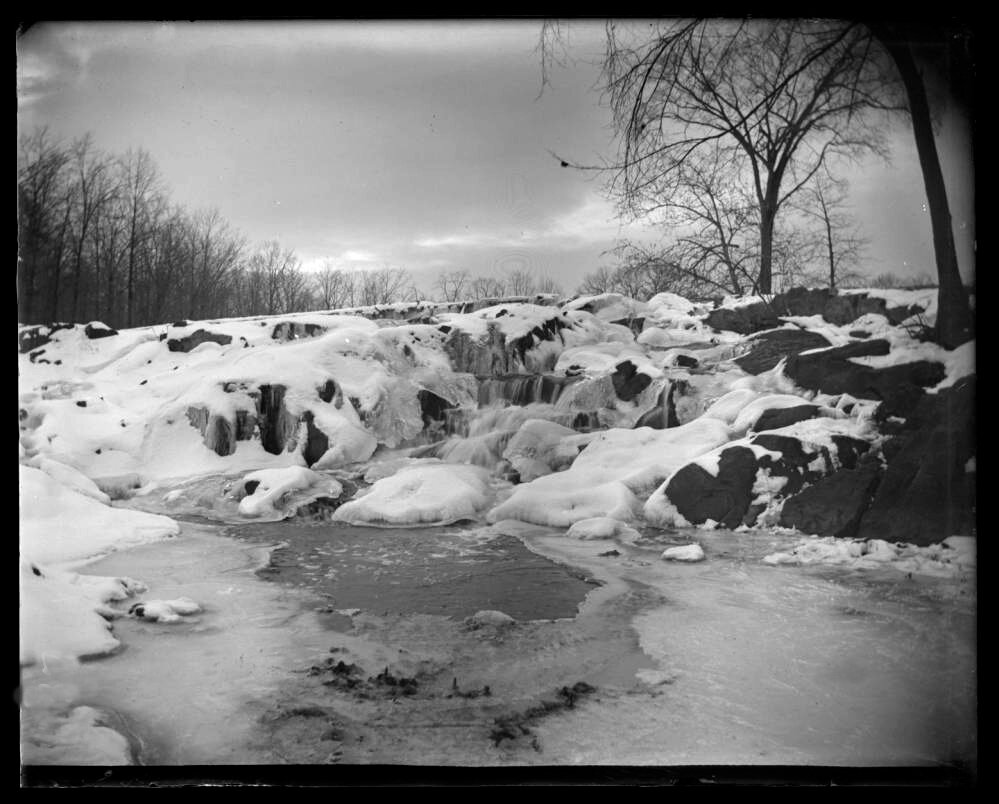
Frozen Falls, 1903. Photo by George E. Stonebridge, New York Historical Society.
In 1701, an English nobleman, Caleb Heathcote had accumulated enough land from Native Americans and settlers, including Anne Richbell, to form the Manor of Scarsdale. It extended from the Bronx River to the Long Island Sound and included the modern towns of Scarsdale, Mamaroneck, Harrison and part of North Castle. Heathcote lost his claim to White Plains to other settlers who had signed duplicate deeds with tribal leaders.
Scarsdale was the fishing and hunting ground for the Siwanoy tribe and for fur traders who hunted the plentiful beavers, otters, wolves, bears, and other animals in the Bronx River Valley. Bison herds were also known to have traveled through the valley.
The Bronx River originates in Valhalla and flows for 23 miles through towns in Westchester and the Bronx before joining the East River and merging with the Atlantic Ocean. The river was a rich source of food and it powered the mills of the early settlers, spurring the growth of towns and industries. Today an alliance of private and public agencies, scientists, volunteers and activists are working to protect the river and its waterfront parks.
For an in-depth look at the history of the Bronx River and the massive efforts to bring it back from severe pollution, watch our documentary, A River Returns, A History of the Bronx River and read the articles below.
Scroll through our articles sequentially or click by topic:
A River Returns, A History of the Bronx River tells the story of the river’s remarkable history, sorrowful decline and the unique efforts to reclaim the river by the communities it flows through.
Historic Places on the Bronx River

1915 Bronx Parkway Commission map.
The places described below can be located on a modern map by clicking here. Some of the locations are approximate since the places no longer exist.
1 Reuben Wright’s Mill
Thomas and Reuben Wright were brothers who settled in Kensico Village in 1720 and operated a grist and sawmill on the Bronx River. During the Revolutionary War General George Washington and other top commanders used the mill as their headquarters. The mill was originally in the town of Kensico, that was flooded when the Kensico Dam was built, but a stone monument representing a mill wheel commemorates Washington’s stay in Kensico.
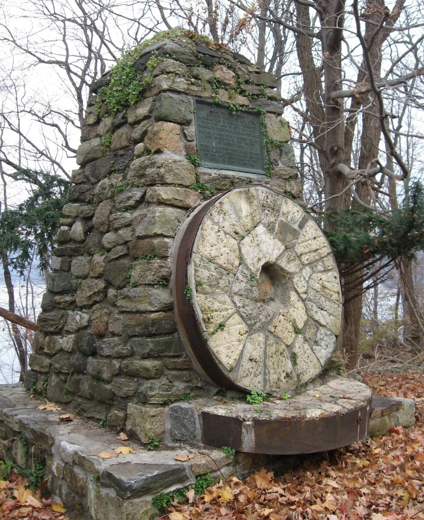
Reuben Wright’s Mill monument. Photo by Michael Herrick.

Reuben Wright’s Mill monument. Photo by Michael Herrick.
2 Kensico Dam
The Kensico Dam is the dramatic point of origin for the Bronx River. The dam, which was completed in 1917, forced the relocation of the town of Kensico, which was dismantled and flooded. The original springs of the Bronx River now flow under the reservoir. This reduced the volume of the Bronx River by 25 percent and diverted its headwaters to Davis Brook in Valhalla.

Kensico Dam. Photo by Lesley Topping.
The walls of the Kensico dam are 307 feet high and 1,843 feet long, and the reservoir extends for 13 miles between the towns of North Castle, Valhalla and Harrison. The Reservoir holds up to 30 billion gallons of drinking water that is piped to New York City and towns in Westchester. The dam was built before poured concrete was common in construction and the ornate masonry walls are made from rocks that were quarried and laboriously moved from nearby Cranberry Lake. The dam is part of the Bronx River Parkway Reservation and is listed on the National Register of Historic Places.

Building Kensico Dam, 1915. Courtesy of the New York Public Library.
3 Kensico Dam Plaza Memorials
The Rising in Kensico Dam Plaza is an 80-foot high memorial for Westchester residents who lost their lives as a result of the September 11, 2001 terrorist attacks. Their names, with quotes from family members, are engraved on the base of the open structure, which was designed by Frederic Schwartz. Paths from the Rising also display memorials for soldiers who lost their lives in operations in Iraq and Afghanistan.
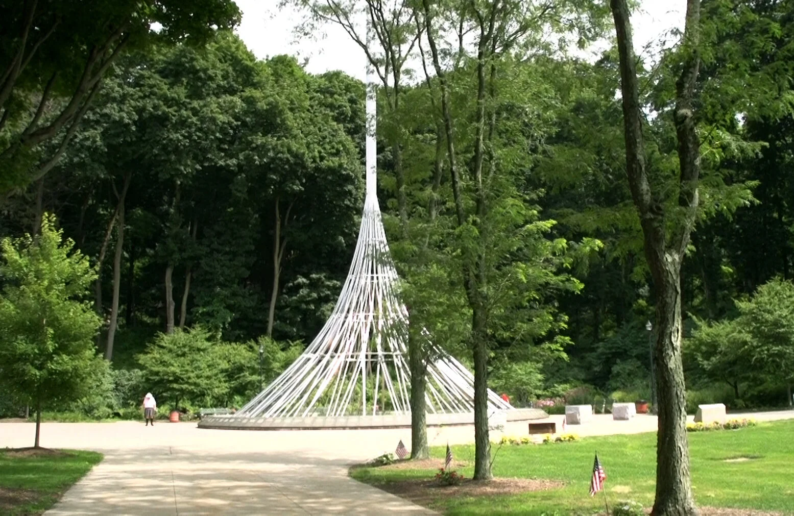
The Rising is a 9/11 memorial at Kensico Dam Plaza. Flags and plaques on the right honor veterans who served in Iraq and Afghanistan. Photo by Lesley Topping.
4 Chatterton Hill (Battle Hill) in White Plains

A White Plains monument displays a British field gun that was used during the Battle of White Plains. Photos by Bill Coughlin.
During the American Revolution the rolling hills above the Bronx River at the border of White Plains and Scarsdale were covered by dense forest and fields separated by stone walls. The Battle of White Plains was fought on this rough terrain on October 28, 1776. The fiercest part of the battle took place on Chatterton Hill when 1,600 Rebel forces courageously held off an advancing army of British and Hessian soldiers. The skirmish was over in less than 30 minutes with causalities on both sides estimated between 100 and 200 soldiers. The Americans were overwhelmed and forced to retreat but heavy rains and a swollen Bronx River deterred British General William Howe from pursuing Washington’s troops. Howe decided to turn back to Manhattan and Washington escaped to North Castle to rebuild his army.

The monument reads: “Near this spot the British under Howe forded the Bronx River and attacked the right wing of Washington’s Army located above on Chatterton Hill. Erected by act of Congress, May 18, 1926.”
5 Bronx River Gunpowder Mills, Hartsdale
Between the Bronx River Parkway and Greenacres Avenue across from the Hitchcock Presbyterian Church is a small park known to residents as Ann’s Way, named in memory of Ann Helen Lund Jacobs (1908-1978). The small pond was originally formed to power the Bronx River Gunpowder Mills.

Lego Brother’s Mill at Ann’s Way. Courtesy of the Scarsdale Library.
Ernest Haubold was a Polish immigrant and successful entrepreneur who built the company in the 1840s. He sold gunpowder to the United States government during the Mexican War and dynamite to the railroad industry. Two fatal explosions hastened the shutdown of the factory. The mills were sold to the Lego Brothers who produced lithographic materials. The Bronx River stills flows down a portion of the original stone foundation of the mills.

A portion of the original mill’s foundation under the bridge at Ann’s Way has been preserved. Photo by Lesley Topping.
Anne’s Way on the Bronx River Parkway Reservation, 2018. Photo by Lesley Topping.
6 Fountain Terrace Gardens, Scarsdale
E. F. Haubold built a beautiful home near his gunpowder factory, which Greenacres developers later turned into a fancy teahouse with Italianate fountains. Despite community efforts to save Fountain Terrace Park in 1967, the fountains and the surrounding park land were removed to widen the Bronx River Parkway.

Fountain Terrance Gardens. Courtesy of the Scarsdale Library.

Fountain Terrance Gardens. Courtesy of the Scarsdale Library.
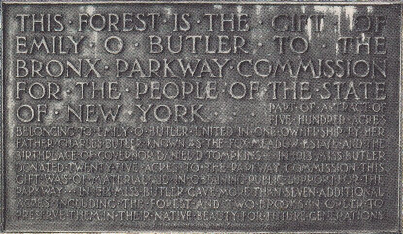
7 Butler Woods, Scarsdale
Emily Butler donated a beautiful section of forest along the river to the Bronx River Parkway Commission. She was a wealthy landowner and prominent resident of Scarsdale. She inherited over 500 acres of property from her father, Charles Butler, who named his estate Fox Meadow.

Emily and Charles Butler. Courtesy of the Scarsdale Library.
Emily Butler allowed neighbors to skate on the ponds and roam freely, provided they walked or used horse drawn carriages; no cars were allowed. Miss Butler was a progressive woman who supported the Suffragettes campaigns for women’s voting rights. She also donated the Wayside Cottage to the Village of Scarsdale which became the first home of the Scarsdale Woman’s Club and Scarsdale Library. A tablet in Butler Woods acknowledges her land contribution that helped complete the Bronx River Parkway Reservation in Scarsdale.

Butler Woods. Courtesy of the Scarsdale Library.
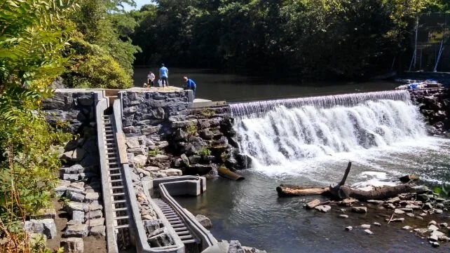
8 Scarsdale Falls
Scarsdale Falls on the Bronx River Parkway Reservation are across from the Scarsdale train station. The dam powered Samuel Crawford’s grist and sawmills in the mid-1700s. He was a dedicated patriot who attended the reading of the Declaration of Independence on the steps of the White Plains Courthouse in 1776. He fought and survived the Battle of White Plains but was killed the following year during a raid by British soldiers in Eastchester. He is the first known Scarsdale resident to die in the Revolutionary War. Major William Popham, an aide to Washington and veteran of the Battle of White Plains, bought the mill from Crawford’s son who had also fought in the battle with his father.

Scarsdale Falls. In the 1700s this was a grist and sawmill dam owned by the Crawford and Popham families. Photo by Antonio Rosario.

Marker for Captain Samuel Crawford, who died during the Revolutionary War.
9 Garth Woods, Scarsdale
Between Harney and Crane Roads, the Bronx River Parkway divides and passes through shady woods of tall elm, tulip and maple trees. The Sierra Club designated this stretch of land along the river as an ancient forest. The woods consist of 60 acres of land originally owned by David J. Garth, a wealthy citizen of Scarsdale. The Parkway commission spent 9 years in court battles trying to acquire the property, which the Garth estate had valued at over a million dollars. In 1924, after the death of David Garth, they finally settled on a sum of $204,940.40.

Garth Woods. Photo by Antonio Rosario.

Garth Woods. Photo by Antonio Rosario.
10 Tuckahoe Marble
Deposits of marble were discovered along the Bronx River in 1822. Alexander Masterton, a Scottish stonecutter opened a successful quarry which encouraged a booming industry. Tuckahoe marble was valued for its beauty and quality. It was popular in Greek Revival buildings throughout the country. The quarries employed Scottish, Irish, Italian and African American workers and many of their families settled in the Bronx River Valley. Financial troubles and competition from marble quarries in Vermont caused most of the quarries to close by the 1930s.

Tuckahoe Marble Quarry, 1900. Courtesy of the Westchester County Historical Society.
The Bates Marble Quarry was on the border of Scarsdale and Eastchester. When the quarry was closed and eventually filled with water it became a popular—but forbidden—place to swim. In 1964, after a number of drowning accidents, the quarry was filled in and turned into Little League baseball fields.

The Bates Marble Quarry on Lakeview Avenue in Eastchester, 1905. Courtesy of the Eastchester Historical Society.
11 The Old Stone Mill, Tuckahoe
Past Crestwood Lake at One Scarsdale Road on the banks of the Bronx River in Tuckahoe is one of two last standing mill buildings on the river. The original mill was built about 1812 and produced cotton cloth and thread, mostly by the labor of young women. In 1852, the mill was sold to the Hodgeman Rubber Factory, which produced rubber products and garments for soldiers during the Civil War and World War I.

Old Stone Mill, circa 1900. Courtesy of the Eastchester Historical Society.

Old Stone Mill Restaurant in Tuckahoe, 2018. Photo by Richie Westlein.
12 The Underhill Crossing, Bronxville

A male North American beaver. Photo courtesy WikiMedia Commons.
Lake Bronxville’s first settlement was named Underhill’s Crossing. The Underhills owned a saw and gristmill where Pondfield Road West crosses the Bronx River. Beavers living at the foot of their garden helped form their millpond. James Prescott Swain bought the mill in 1844 and opened a water-powered stone factory that produced screws and axles. Alfred Ebenezer Smith built his axle factory on the Bronx River across from Swain’s mills. Bronxville was a busy manufacturing hub until 1922, when a huge fire burned down the Kraft Leather Tannery, the last of the big factories there.

Bronxville Lake. Photo by Lesley Topping.
13 The Lorillard Snuff Factory/New York Botanical Garden

One of the original mill buildings of the Lorillard Tobacco Company has been beautifully restored in the New York Botanical Gardens. Pierre Lorillard, an immigrant from France, founded the company in Manhattan, and popularized the use of high quality ground tobacco (snuff). However, he would not live to see his company’s nationwide growth. He fought in the Revolutionary war and was killed in 1776 by Hessian soldiers when the British Army overwhelmed New York City. His sons, George and Peter moved the business to the Bronx River in 1790. The company was forced to relocate in 1884 when New York City purchased their land for Bronx Park. Their company eventually grew into a multimillion-dollar industry. One of its popular brands was Newport cigarettes.

Lorillard mill wheel, 1911. Courtesy of The Library of Congress.

One of the Lorillard Mill buildings was restored at the New York Botanical Garden. Photo by Jim Griffin.
14 The Bolton Bleach Factory/Bronx Zoo
Along the Mitsubishi River Walk in the Bronx Zoological Society, visitors can view the dams that powered the Bolton Bleach Factory in the 1800s. Pollution from this factory and others in West Farms contributed to the deaths of hundreds of water birds in the early 1900s. When people started shunning the park and boating because of the smells from the river, zoo officials were galvanized into cleaning up the Bronx River by urging the creation of what became the Bronx River Parkway Reservation.

A dam at the Bronx Zoo originally powered the Bolton Bleach Factory. Photo by Antonio Rosario.

The Bronx Zoological Society Boathouse, circa 1900.
15 Delancey Mills/Bronx River Falls
Bronx River Falls in West Farms ran the first known mills on the Bronx River. The land was deeded to William Richardson and his partners in 1680. During the American Revolution the mills were owned by the DeLanceys who were prominent citizens throughout Westchester. James DeLancey was the High Sheriff of the County under British Rule. He remained loyal to the King throughout the American Revolution and led murderous raids to supply British troops. The mill was confiscated after the war and sold to the Lydig family who ran the mills until New York City took over the land to form the Bronx Park.

This postcard displays the Bronx Zoo’s boathouse behind Bronx Falls, which was the first known mill dam on the Bronx River. The mill was established in 1680.
Not all the DeLanceys were loyalists. Susan DeLancey, whose grandfather, Caleb Heathcote, founded the Manor of Scarsdale, married author James Fenimore Cooper. They moved to Scarsdale where he wrote the novel, The Spy, set in Westchester during Revolutionary War. Peter DeLancey, another grandson of Heathcote, was influential in Mamaroneck. The family also owned a large farm in Scarsdale that bordered the Bronx River near Hartsdale and White Plains.

Bronx River Falls, circa 1902, and the abandoned Lydig Mills. Courtesy of the New York Historical Society.
In the 1970s the Bronx River in West Farms had become a severely polluted dumping ground for garbage. Massive cleanups were organized by activists and the Bronx River Restoration. The organization grew into The Bronx River Alliance and together with the NYC Parks Department they partner to protect the River and its waterfront parks.
In 2015 a fish ladder was installed at Bronx Falls by the Bronx River Alliance to help alewives herring swim upstream to spawn.
16 Starlight Park, Bronx
The newly restored 13-acre Starlight Park is part of the Bronx River Greenway, a plan to connect pathways and parks along the full length of the Bronx River. The original Starlight Park was created from the 1918 Bronx International Exposition of Science, Arts and Industry Fair. It was a popular amusement park with swimming, rides, a large rollercoaster and Coliseum where 1,500 people could watch sports and other events. Open-air operas were also preformed to crowds and broadcast over the radio. The enormous pool, which used filtered water from the Bronx River, had a wave making machine, floats and a sand beach. Financial troubles during the depression forced it to close in the 1930s.

Starlight Amusement Park.
17 Concrete Plant Park, Bronx
The Transit-Mix Concrete Plant originally built in 1940 off Westchester Avenue was abandoned in 1987 and deteriorated into a dumping ground. However, neighborhood activists led by the Youth Ministry for Peace and Justice, mobilized to turn the space into a park and to prevent New York City from running a truck route through the area. With the combined efforts of public and private agencies it became a unique park. The silos were restored, salt marshes were planted, a playground was installed and visitors can bike and fish along the river.

Concrete Plant Park, before 2004. Courtesy of the Bronx River Alliance.

Concrete Plant Park, 2018. Community activists initiated the creation of the park in 2009 from an abandoned factory.
18 Clason Point, Bronx
Clason Point sits at the mouth of the Bronx River where it enters the East River and features a spectacular view of Manhattan and Brooklyn. Called “Snakapins” or “Land of Two Waters” by Algonquin people, it was the site of several large Siwanoy tribal settlements. Oysters were an abundant food source for the indigenous tribes and other settlers until pollution and over-fishing depleted the oyster population. Today efforts are underway to restore the oyster reefs that can act as natural filtration against pollutants.

Clason Point was also famous for its amusement park with an enormous swimming pool to rival the one at Starlight Park. In 1922, tornado winds blew down the 75-foot Ferris wheel killing six people and injuring 27. The owner was arrested for homicide and the park never fully recovered and closed within a few years. In 1949, a popular private beach resort, Shorehaven, with lively entertainment and comic shows took its place until the 1980s.

Clason Point Park Ferry Landing.

Clason Point Park Salt Baths.
The Bronx River: Boundary of Indian Tribes, Colonies, Manors, Cities and Villages
By Barbara Shay MacDonald
This article was originally published in the Scarsdale Historical Society Magazine in 2005.

Landing of Hedrick Hudson by Robert Walter Weir. Courtesy of the New York Public Library.
In 1609, when Henry Hudson sailed up the river that would later bear his name, he saw people of the large fishing village of Nappeckamack at the mouth of the Nepperham River in Yonkers. This is just four miles north of the Manhattan’s fortress at Spuyten Duyvil Creek. As he sailed farther up the river he was astonished to find Native American villages at the mouth of nearly all the smaller streams flowing into it. Five miles further he found the western capital village of the Weckqueskeck tribe at the mouth of what is now known as Wickers Creek in present day Dobbs Ferry. He passed other villages in Tarrytown, Ossining, Croton Point and Peekskill. These Native Americans were part of the Wappinger Confederation of eight tribes, who resided on the banks of the Hudson at its tributaries. These were the Nepperham (Saw Mill River), the Sprain, Tibbet's Brook (the Mosholu), and Aquehung (the Bronx River). Historians estimate that the population of the entire confederation was only 5,000 in 1600.
The eastern boundary line for the largest tribe, the Weckqueskeck, was the west bank of the Bronx, the same line that would emerge much later when Manors were established by the Dutch and the English and again when towns, cities and villages were designated after the Revolution. The east bank of the river was the boundary for the Siwanoys, clammers and fishermen, who were also part of the confederation. Their land extended along the Long Island Sound from Norwalk to Hellgate. Early settlers reported that Davenport Neck was covered with wigwams. There were native villages at Rye Pond, Rye Neck, Parsonage Point, Wampus Pond, the mouth of the Mamaroneck, and Bronxville. Their large burying ground was at Pelham Neck. Since Scarsdale was on the east bank of the Bronx and belonged to the salt water loving Siwanoys, it never did have a settlement, but was certainly used as a hunting ground for local tribes.

Map of Westchester in 1609 by Barbara MacDonald.
Weckqueskeck Villages
All the nearby Weckqueskeck villages, Quorropos (White Plains), Tuckahoe (Yonkers) and Aquehung (nearby to Scarsdale in Strathmore, Cedar Knolls and close to Bronxville) were on the west bank of the river. Another nearby village was in present-day Bronxville, atop what is known as "Sunset Hill", the former site of the Hotel Gramatan, named for its Siwanoy Sachem. In 2003, our Scarsdale Historical Society journal article told of Scarsdale children and adults entering a traditional wild race of washtubs in the Bronxville section of Eastchester on the fourth of July in the mid 19th century. In December 1948, the directional flow of the Bronx River was changed to eliminate a curve and create land in the old riverbed in order to construct an addition to Lawrence Hospital. During the excavations a large sand bar was uncovered, and that indicates that when the river was wider, sand accumulated at the bend over hundreds of years and made a sandy beach, perfect for beaching Indian canoes. Perhaps that is also just the spot where the washtubs inevitably overturned at the end of the race!
Bronx River Valley
Natives called the Bronx River Valley “Laaphawachking”, “the place of the stringing beads”, because its most prominent feature was a series of beaver dams that turned the river into a string of lakes. Trout, sunfish, suckers, minnows and snapping turtles abounded, as did wolves, bears, wildcats, deer, otter, weasels, beavers and muskrats. An occasional herd of bison from the Highlands and the North Salem area wandered to graze in open areas created by forest fires. Rattlesnakes were a continuing problem for the early European settlers, as were wolves. In Eastchester in 1665, the settlers drew up 27 rules in articles of agreement. Number 21 stated that one day every spring would be set aside for the destroying of rattlesnakes. Wolf pits abounded, and in 1672 the Provincial Assembly issued a payment of 20 shillings for a grown wolf killed by a Christian, and 10 shillings for such a wolf killed by an Indian.
The Bronx River starts at a hill about 650 feet above sea level in what is now the Town of New Castle. Since there was no Kensico Dam, this portion of the valley was a wide plain surrounded by hills, called Quoropos, meaning white marshes. This referred to the ever-present mists caused by the convergence of four large streams from the west and the east. There were eight main beaver dams in the Westchester County, more in the Bronx, all later made into milldams by the settlers. Three will be familiar to Scarsdale residents, as the first was near the Hartsdale Railroad Station where the Hart's Brook joins the Bronx. The next, at Popham Bridge, became Crawford's Mill, and the third was Underhill's Mill in Bronxville. The river, only 30 miles long as the crow flies, finally squeezes through the narrow gorge in the Bronx at the New York Botanical gardens, then widens, becomes tidal, and empties into the East River and finally the ocean.
Edgemont Settlements
After the Europeans began to push the Weckqueskeck from their villages, and after most of the tribe was decimated in the Dutch Indian Wars, some of the survivors chose to move inland and two small settlements were made in Greenburgh, in the area we know as Edgemont. Bolton, in his History of Westchester County, writes:
“Hart’s Corners, formerly Barnes’ Corners, is a small hamlet in Greenburg. A fine line of hills extend south from Hart’s Corners to the foot of Thirty Deer ridge in Yonkers, watered on the east and west by the two branches of the Sprain, called by Indians Armenperal. These hills were formerly so covered with thick woods as to be impassable, and abounded in deer, wolves, bears, wildcats and rattlesnakes. One of the earliest settlers (1731) of the place was John Tompkins of Eastchester. Tompkins was in the constant practice of spending the week here and returning to his family on Saturday. During the whole of this period he was surrounded by Indians, but they never once offered to molest him. A small hill to the southeast of the present Mr. John Tompkins, still bears the name of Indian Hill, and the adjoining spring is called the Indian Spring.”

Map of tribal settlements from Incidents from Westchester’s History by Helen L. Hultz, Westchester County Publications Committee, 1934.
Of great interest to Scarsdale readers is that John Tompkins of Eastchester bought farmland on the west side of the Post Road. He had four sons, and some of them farmed the land in Scarsdale. After his death, and several family wills and sales, the land was eventually sold to Thomas Hadden, and became the beginnings of Wayside Cottage. One of Tompkins’s sons, Thomas, married Abigail Heddy (Hadden, Haddan), the daughter of Thomas Haddan of Wayside. They had seven sons, one of whom, Nathaniel, settled in Greenburgh.
Louise Clark, Edgemont historian, tells us that there were two Native American encampments as late as 1746, and the Tompkins “Indian Hill” encampment is now the property of Hillard Day Camp at 26 Elizabeth Street in Hartsdale. The second encampment stood on the farm of James McChain along the Sprain Brook near 380 Underhill Road (Greenville).
One by one, the Westchester tribes began to dwindle, and eventually fade away as the settlers encroached on their land. As late as 1694 and 1695 Native Americans were in the habit of coming from the White Plains area to New Rochelle to join in a fall cider frolic. In 1667 a small group visited, and were never seen again. At about the same time, a clergyman in Rye said that their 20 Native families had dwindled to 10, and then disappeared entirely. By 1756 most of the Natives who were left had joined a tribe in Broome County, or moved to Stockbridge, Massachusetts. The remnants of those Stockbridge Indians moved in 1785 to join the Oneidas in Madison County, New York and about 1818 they moved again to Ohio. The last spot in Westchester that was occupied by Natives was Indian Hill in Yorktown, where they remained until 1804. According to the census, only 15 “civilized” Indians were living in Westchester in 1880, and in 1890 there were only four. All that is left today is legend, and the wondrous Indian names throughout our County.
Barbara Shay Curran MacDonald is Scarsdale Historical Society Historian and Vice President of the Board of Trustees.
The American Revolution Along the Bronx River
During the American Revolution events along the Bronx River would reflect the turmoil of divided loyalties among Westchester residents. Farmers, soldiers and families would be split over whether to side with the Patriots or England. The Battle of White Plains was one of the major conflicts along the Bronx River.
The Weckqueskeck people called the River Aquehung, meaning “fast stream flowing along a high bluff,” a perfect description of the topography where the Battle of White Plains was fought. In 1776, the rolling hills above the river in Scarsdale and White Plains were covered by fields divided by stone walls and surrounded by dense wooded forest, ideal conditions for rebel attacks and defensive maneuvers against the British Army.

View from Chatterton Hill looking east across site of Battle of White Plains, circa 1870s. In the foreground is Battle Avenue. White Plains Collection, White Plains Public Library.
Chatterton Hill, also known as Battle Hill, rises about 180 feet above the Bronx River and it is where the fiercest skirmish of the battle occurred between American and British troops joined by thousands of well-trained Hessian soldiers hired out to King George III by German rulers. The Battle of White Plains on October 28, 1776 was short but deadly. It was one of the pivotal incidents leading to the British occupation of New York and it allowed General George Washington’s troops to safely retreat and rebuild his army.
Prior to the battle, on August 27, 1776, the Continental Amy had suffered a terrible defeat in the Battle of Long Island, also known as the Battle of Brooklyn. However, Washington’s troops eluded capture by stealthily escaping to Harlem Heights where they were able to secure strong positions in northern Manhattan.

General Sir William Howe.
On October 12th, 80 vessels commanded by British General Sir William Howe landed on Throg’s Neck to secure passage through the Hudson River and trap Washington’s Army but this proved to be a bad decision. Howe was delayed for days waiting for supplies and met resistance from rebel troops who foiled his plans to move his men off the narrow peninsula between the East River and the Long Island Sound. Meanwhile, the American war council decided that Washington should evacuate most of his army from Harlem Heights to defend his flank in Westchester. A garrison was left at Fort Washington and Washington’s army began the slow difficult march to White Plains. Four divisions were commanded by Generals Lee, Heath, Sullivan and Lincoln and they marched with cannons pulled by men, horses and oxen over rough terrain. British General Howe’s ships pushed on to Pell’s Point near New Rochelle and by October 20th he had troops in Mamaroneck and Scarsdale. He would use Jonathan Griffin’s house on Mamaroneck Road as his headquarters. The house, which still stands, was built on a high hill, on the west side of the River and provided a good view of troop movements of both armies. On October 22, reinforcements of 4,600 Hessian troops and 3,400 British landed in New Rochelle. Terrified Westchester residents fled as soldiers raided homes and farms.
By October 28, both armies had positions on the east and west sides of the Bronx River. American General Joseph Spencer’s men were placed near Fenimore Road on the high ground between Scarsdale and White Plains. In late morning, they fought the first skirmish of the battle in Greenacres. The second deadly advance occurred on Chatterton Hill lasting only 15 to 30 minutes. Four thousand Hessian and British Troops ascended the hill against 1,600 Americans. The Americans held off an advancing well-trained army twice their number. The British and Hessian soldiers crossed the Bronx River and climbed the steep rocky inclines and slippery mud to reach the Americans. Rebel troops held them off but eventually fled from British and Hessian regiments of Light Dragoon horsemen attacking from an alternative route.

The Battle of White Plains painting by E.F. Ward was also the design for a two-cent postage stamp in 1926.
Colonel Haslet of the Delaware regiment wrote, “The air groaned with streams of cannon and musket shot, the hills smoked and echoed terribly with the bursting of shells, the fences and walls were knocked down and torn to pieces…bodies mangled with cannon and grape shot all around us.”

Map of troop movements at the Battle of White Plains by Otto Hufeland, from his book Westchester County During the American Revolution, 1775-1783.
Casualty counts were estimated between 100 and 250 for each side. British and American accounts of the battle on Chatterton hill differ, the British claim to have steadily and slowly attacked the Americans and forced their retreat. The Americans claimed to have twice forced back the enemy before they fled. The next day heavy rains and a swollen Bronx River helped prevent Howe’s immediate pursuit of the Americans and Washington’s army packed up to make their way to the town of North Castle. General Howe decided not to follow them through the difficult terrain and on November 5th he turned his army back to Manhattan. This fateful plan led to the horrendous defeat of the Americans at Fort Washington in Northern Manhattan. Hundreds of men lost their lives and thousands of rebel prisoners would languish and die in horrible conditions on the prisons ships anchored in New York harbor. Washington successfully retreated and would start to rebuild his wounded and tattered army.
Click here for a vivid account of the battles of Brooklyn and White Plains by Major Benjamin Tallmadge.
Bronx River Mills During the American Revolution
A plaque in the town of North Castle near Kensico Dam proudly commemorates that Reuben Wright Mills, an early mill on the Bronx River, was George Washington’s Headquarters for a short time.

Monument for Reuben Wright Mills. The plaque reads: “Near this site stood Reuben Wright Mills. Headquarters of General Washington from July 20th to 25th, 1778. Also occupied by other Revolutionary Generals. The Mills were in Old Kensico Village now inundated by the waters of the Kensico Lake. These millstones were placed by the White Plains Chapter D.A.R. Oct. 20th, 1932, on the 156th Anniversary of the Battle of White Plains, 1776.” Photograph by Michael Herrick, 2009.
In Scarsdale, another Bronx River miller, Captain Samuel Crawford and his son fought in the Battle of White Plains. The following year on November 18, 1777 Crawford was bayoneted and killed in a raid by British soldiers. He is the first known Scarsdalian to die in the Revolutionary War. A tablet honoring him was erected in Eastchester by the Daughters of the American Revolution in 1913.

Monument honoring Captain Samuel Crawford, the first known Scarsdalian to die in the Revolutionary War.

Loyalist Colonel James DeLancey owned one of the Bronx River mills in West Farms.
Major William Popham, an aide to Washington and a hero in the Battle of White Plains bought Crawford’s mill. The mill’s picturesque waterfall is now part of the Bronx River Parkway Reservation, across from the Scarsdale train station.
Further south in West Farms, a fervent loyalist family, the DeLanceys, owned an early Bronx River mill. Colonel James DeLancey, known as the “Cowboy of the Bronx”, and his gang of thugs on horseback mercilessly plundered farms and homes throughout Westchester. Caught between two armies and divided sympathies, the people of Westchester would suffer greatly on ‘Neutral Ground’ throughout the Revolutionary War period.
Fredrick Van Wyck Cleans Up Scarsdale

Illustration of Frederick Van Wyck from his book Recollections of an Old New Yorker, 1932.
Fredrick Van Wyck (1853-1936) is a colorful character in the history of Scarsdale. He stood out with his signature curled mustache and distinctive beard, and held several important public service positions in Scarsdale.
His persistence helped clear up some of the stench swirling around Scarsdale from the Bronx River. In the early 1900s, one of the culprits responsible for polluting the river was a White Plains sewage deposal plant on the border of Scarsdale and White Plains. Years of complaints by residents hadn’t helped and industrial waste from the nearby Bronx River Gun Powder Factory only added to the problem. In 1904, Scarsdale’s Town Club made it a priority to control the overflow from the disposal plant and construct a better sewer system.
Fredrick Van Wyck was an active member of the Town Club. He lived in a house (that still stands) on Fenimore Road at the corner of Oak way in Greenacres, which was a short distance from the plant and the Bronx River. He was determined to solve the problem. In his amusing memoir, Recollections of an Old New Yorker, he wrote:
“Well, I was the special deputy sheriff of Westchester County, one of the highway commissioners, Scarsdale’s treasurer and trustee of the school system, chairman of the Republican committee, vice president of the (St. James) the Less, Vice President of the Volunteer Fire Department and they must have thought that I did not have much to do with my job in New York, for they kindly gave me another, trying to stop the nuisance from the White Plains works.”
After repeated court delays on efforts to control the sewage overflow from the disposal plant, Van Wyck made an unusual discovery. Examining old maps, he found that a horseshoe loop in the River had been straightened “100 years before” to provide more waterpower, and “White Plains had forgotten the straightening of the river and had built their works on the property belonging to the Town of Scarsdale.”
This was a game changer, and Van Wyck quickly called a Town meeting where he “was authorized to stop the nuisance.” “Going to the works with hammer, nails, locks and seals” Van Wyck told Harry Dykman, head of the White Plains Corporation, of his intention as Deputy Sheriff to seal the plant in the next two hours, which would “back up all the sewage in the houses of White Plains.”
Harry responded quickly, Van Wyck recalled, “In those days, horses were our only means of transportation, but Harry rushed down to my house as fast he could, and I showed him a tracing of the map on file . . . He cried, “I think you have us by the throat but for God’s sake, give me a chance, otherwise we will have a pestilence!” I said, “All right . . . you must agree that you, representing White Plains, will back me up in putting through the bill for the Bronx River sewer.”

The highlighted box shows the original path of the Bronx River and the White Plains disposal plant on the Scarsdale side of the Bronx River. Courtesy of the White Plains Library.

Van Wyck with his dogs in Scarsdale. Illustration from Recollections of an Old New Yorker.
According to Van Wyck, this finding helped Scarsdale win the support they needed to construct a more efficient sewer system and pass the bills for the Bronx River Parkway Reservation. He also enjoys highlighting the roles of Scarsdale’s prominent residents in these events and writes, “The men who should receive most credit for the Bronx River Parkway and Sewer are both dead—Charles Butler who owned Fox Meadow, the beautiful five hundred-acre estate opposite my place, gave thirty acres for the sewer . . . and Welcome G. Hitchcock who owned “Green Acres” part of which contains some of my forty three-acres, that I previously sold to Hitchcock. He also gave some land for the Parkway. They were both very enterprising citizens and always liberal in any movement. Without them I doubt if the Bronx River Parkway would ever have been built.“
However, it should be noted that Charles Butler’s daughter, Emily Butler was also very instrumental, and donated some of her property for the Bronx River Parkway Reservation. A plaque acknowledging her gift can be seen in Butler Woods along the Bronx River.

The plaque acknowledging Emily Butler's gift to the Bronx River Parkway Reservation can be seen in Butler Woods.